/
      • More than 50% of the ranch (more than 80 square miles) is deeded land, in Arizona, a state that is overwhelmingly (greater than 85%) government owned.
      • Is located almost entirely within the boundaries of the Prescott National Forest. It is the last large parcel of checkerboard holdings in the National Forests in the Southwest, and the Forest Service had previously attempted to do a land exchange to obtain these inholdings.


      • Crosses a variety of elevations and climatic zones, and includes the largest stand of ponderosa pine in private hands in the state.
      • Is generally well watered, very unusual in normally dry Northern Arizona, with twenty wells and or springs.
    • The Yavapai Ranch is located in the Northern half of Yavapai County, one of Arizona's four original counties. Its Northern border is 12 miles South of the small town of Seligman, located on I-40, the main line Santa Fe railroad, and the historical U.S. Route 66. Yavapai County Route 5, a county-maintained unpaved road, bisects the ranch and connects it to Prescott and Seligman. Its Southern boundary is about 35 miles north of Prescott, the first capitol of Arizona and the county seat. The Ranch is less than 3 hours drive from Phoenix to the South; it is about three hours drive to Las Vegas to the northwest. It is also less than six hours by car from the Eastern Los Angeles suburbs, making it the potentially the closest developable forested property to both Las Vegas and Los Angeles!

      For private aircraft Seligman has an airport with a paved and lighted runway; Prescott has a larger airport with scheduled commercial air service.

      Two separate power lines provide limited power to the northern parts of the ranch. An important 230 kW transmission line crosses the southern part of the ranch, and is of great interest to solar and wind power companies, as it is one of the few lines in the southwest with extra capacity available. The Yavapai Ranch has been labeled the best potential commercial wind site in Arizona.

    • History

      Yavapai Ranch History

      The current Yavapai Ranch includes what were once five smaller ranches. The origin of the oldest of these is first mentioned in 1867, when a group of cowboys pursued some Indians who had stolen some of their horses. The cowboys found the Indians camping by a small spring-fed marsh. The next year the spring was homesteaded, so that the Yavapai Ranch is one of the oldest continually operating ranches in Arizona. A second homestead in the Southwest of the ranch provides a picturesque remote settlement with a log cabin that is the second or third oldest pioneer building standing in Yavapai County.

      The bulk of the private land on the ranch was part of the land grant under the Atlantic and Pacific Act of 1866 by which the first four transcontinental railroads were given alternate sections in a checkerboard formation on either side of the railroad.

    • In the National Forest

      Almost the entire ranch lies within the borders of the Prescott National Forest. It is the last large railroad checkerboard within the National Forest boundaries in the southwest. In fact, the Ranch constitutes more than 90% of all the undeveloped inholdings within all the National Forests in Arizona.

      The U.S. Forest Service has had a long-standing policy of attempting to buy or trade for private inholdings. In furtherance of this policy, the U.S. Congress in 2005 passed an act (P. L. 109-110) specifically to further a land exchange on this ranch to absorb the majority of the checkerboard and consolidate remaining parts. This exchange never occurred.

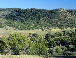
      Many of the sections on the ranch have absolutely fabulous views out over the surrounding lowlands. In many places one can see 75 miles to the San Francisco Peaks to the NE, toward the Aquarius cliffs to the North, and to the Hualapai Mountains to the West.